Showing posts with label Hiking. Show all posts

Friday, November 11, 2016

Bryce's Fairyland Loop

Each ranger at Bryce Canyon National Park has their own slightly different rankings of hiking recommendations to offer visitors when they approach the information desk.  Some love to recommend the less popular hikes first (in hopes visitors will spread out a bit more), while others stick with the tried and true "Queen's/Navajo Combination," noted in the brochure as the park's most popular hike.

I always tried to listen first to what the visitor's fitness level and interests were before prioritizing a list.  If someone was only in the park for the day, and had adequate boots and fitness level, I'd recommend starting with the Queen's/Navajo 3-mile loop, and combining it with Peek-a-Boo for the very best hiking views in the park.

But if someone had multiple days, or was looking for a more solitary, intimate experience within the park, there was never a question as to the hike I'd recommend next... the 8-mile Fairyland Loop trail.


Friday, November 4, 2016

Bryce's Peek-a-Boo Trail

Working the Visitor Center at Bryce Canyon National Park was far different than at Bosque del Apache NWR.  At Bosque, I'd interact with less than 100 people per day, each often asking very unique questions (i.e. showing me their camera LCD and asking "what is this bird/plant/reptile?").

At Bryce, the line of visitors waiting to speak with us at the Info Desk was often long and continuous.  No matter how hard (or how many different ways) we tried, we could never seem to meet the demand of Bryce's exploding visitation (now about 2 million a year).  Exasperatingly, the question from all these visitors was almost always the same:  "what's the best hike?"


Monday, October 31, 2016

Getting Familiar with Bryce

My first two weeks at Bryce Canyon National Park in late July were filled with activity.  From learning my new job (as a volunteer interpretive ranger), to learning my way around my new 35-mile radius "neighborhood."

The first day on the job consisted of orientation, an easy day of being a tourist and exploring the same sights that they do.  I hopped on the free shuttle bus and took a hike along the rim to refamiliarize myself with the most popular lookouts-- Inspiration Point, Sunset Point, and Sunrise Point.

The midday sun was not ideal for photography, but Bryce still manages to look amazing at just about any time of day (or night!).  Here's the view looking down into Queen's Garden:


Tuesday, October 11, 2016

On to Bryce via Colorado

Continuing my westward July travels, after a couple more "Camp Wally" overnight stops at the Scottsbluff, NE and Laramie, WY Wal-Mart stores,  I decided to bypass Denver's traffic and head to the central Colorado mountains via 2-lane mountain roads from Wyoming instead.

Along the way just so happened to be another National Wildlife Refuge, so of course, I had to stop!  Arapaho NWR sits in the North Park basin west of Rocky Mountain National Park and east of Steamboat Springs.  The auto tour loop was easy to scope out before driving it, so I knew I'd be o.k. driving it with the RV/toad.

There were a few ponds of migratory ducks, geese, and this cute little pied-billed grebe--


Wednesday, August 31, 2016

Giant T@B Cache in Southern IL

Here it is the end of August, and I'm still trying to finish my blog posts of my springtime travels....eee gads!  Well, I've been wildly busy this summer working as a volunteer interpretive ranger at Bryce Canyon NP, and the connectivity here (and spare time) have been pretty minimal.  So, I'll try to mash together multiple posts into one today, and move the backlog along a bit!

My final week in southern Illinois this past April was spent doing the 2 big things I'd come to the area to do: attend the Midwest T@B Rally at Giant City State Park, and finally (FINALLY) paddle and explore the Cache river basin-- the northernmost cypress tupelo swamp in North America.


Friday, August 12, 2016

Surprising Southern Illinois

You'd think after being a resident of Illinois for 40-some years, I would have discovered southern Illinois far sooner.  But it always seemed to be "pass-thru" territory as I criss-crossed the region to get to somewhere else.

That was finally remedied this past April when southern Illinois became my home for 2 weeks.  My dear old T@B camping friends were holding a rally near Carbondale, so that became the destination to my 2,000-mile journey back to the Midwest.

Arriving to Carbondale about a week before the rally, I decided to check out Crab Orchard National Wildlife Refuge-- one of the very few NWRs that offers public RV camping with hookups inside its borders.

I arrived just ahead of the weekend warriors and snagged this gorgeous lakefront site for a week.  Just love "first come, first served" campgrounds!


Friday, July 3, 2015

Inspired & Invigorated at Starved Rock

After my hectic first week back in Illinois in early May (which culminated in a insurance fiasco that postponed my cancer surgery until June), I now had 3 extra weeks on my hands.  While I still had plenty of “Pre-Op” errands to-do and lots of local friends to visit, I decided that I first and foremost needed a few days of alone time to be still, fully process my new reality of living with cancer, and to get my internal batteries fully charged and ready for the battles ahead.

Every time I return to the Midwest from a winter spent in the desert southwest, I desperately crave what the desert lacks—water, and the color green!  A few years ago, the Springtime Ozarks of southern Missouri recharged and refreshed me.  But with time so short this year, I had to look for a nearby retreat.  Starved Rock State Park, just 100 miles southwest of Chicago on the Illinois river, would do the trick!

I go to nature

Canyon hikes, waterfalls, lush green forests, and this quote by noted naturalist John Burroughs were sure to inspire:

I go to nature to be soothed and healed,

and to have my senses put in order.

Saturday, April 18, 2015

A Bit of Heaven & Hell - Returning Up the Baja

It was a mere 715 miles from Bahía de Concepción to the U.S. border.  An easy 2-day drive on most U.S. roads, but Baja Highway 1 sets its own rules.  Hans, Ursula, and I decided we would make the narrow, winding, shoulder-less drive in 6 days rather than 2.  After 7 weeks in Baja, we were now moving at the same laid-back pace as most of the locals (rather than that of over-scheduled, over-stressed, and over-stimulated Americans). 

Along the way, there would be gray whales to touch, French baguettes to savor, cactus trails to hike, and plenty of serene beachfront sunrises and sunsets to enjoy.

IMG_7340-Edit

There’d also be a few moments of terror and mishap too…no journey that includes climbing “the Grade of Hell” past 3 volcanoes would be complete without a bit of terror and mishap!

Thursday, December 18, 2014

Classic Scenes from Zion

It’s now been over a month since I completed my first visit to Zion National Park.  It feels almost a whole other world away now as Millie and I are currently enjoying our second winter in Mexico exploring the Baja peninsula.  But whenever I come across a decent WiFi connection here, I’ll keep trying to catch the blog up as quickly as I can!

Even after 2 full weeks in Zion, I felt like I had just barely scratched the surface.  Certainly, some of the “unofficial” hikes revealed a Zion that few tourists often get to see, but photographically speaking, I didn’t make it very far beyond the classic Zion scenes that, no doubt, many thousands of other tourists photograph each year as well.

So for those of you familiar with Zion and these scenes, forgive the repetition of same old-same old.  For others who have not yet experienced Zion for yourself, I hope these images give you a good taste of what this fabulous park has to offer!

Perhaps the most common scene is from the Canyon Junction bridge looking down the Virgin river as The Watchman looms in the background.  I first photographed this scene with about 20 other photographers—all of us standing along the bridge with our tripods vying for the best vantage point.

IMG_6640

Thursday, December 11, 2014

Hiking Zion National Park

I spent 2 weeks at Zion National Park last month and got to meet up with a group of RV blogger-hikers who led me to some pretty incredible places (both on and off the beaten path). 

IMG_6773

The other bloggers posted their trip summaries weeks ago, so I won’t attempt to repeat all their terrific details here.  If you’ve not yet read them, I encourage you to check out Mark & Bobbie’s Box Canyon Blog, Jim & Gayle’s Life’s Little Adventures, and Suzanne’s Take to the Highway

I also greatly enjoyed meeting the non-bloggers of the group— John & Ellen, Debbie, Laurelee, John Q & Joallen.  Thank you all for the fun laughs and pleasant conversation both on and off the trail!

I’m still very much a novice hiker and, as such, spent most of my time huffing and puffing from the tail end of the pack focusing more on simply completing each hike than masterfully photographing them, but I did manage to snap a few shots to share now with you here.

Tuesday, November 25, 2014

Hiking Down Into Bryce Canyon

After seeing Bryce Canyon National Park from the rim at sunset, I was determined to get down into the canyon for a hike the following afternoon.  I reviewed the park handouts and maps and decided to do the moderate-rated Navajo Loop and combine it with an “out and back” jaunt over to the Queen’s Garden while I was down in the canyon.  The total distance would be just over 3 miles with an elevation gain/loss of 550 feet.  A bit of a workout, but very do-able!

Remember this shot from my last post?  A commenter said she was starting to realize the impact that good lighting has on a photograph (such as late afternoon/early morning light versus the mid-day sun).  Well, here’s a perfect example!  This first shot was taken at around 4:30pm, an hour before sunset, as the sun was reflecting incredible “glowing” light off the hoodoos.  Complete magic!

IMG_6078

Now, here’s the same scene the next day as I started my hike (around 1:00pm in the mid-day sun).  Certainly still a great scene with some nice glowing hoodoos, but surely not the magic as the first shot.   Yes, indeed, lighting is a crucial element for a great photo!

IMG_6096

Now, let’s get on with the hike!

Wednesday, November 19, 2014

My 1st Slot Canyon – Didn’t Make It Very Far!

Moab graced us with a final glorious sunrise as Suzanne and I prepared to pack up our Winnies and head off to separate canyons.

IMG_2520

Suzanne was headed back to her special place, Snow Canyon, near St. George.  While I had my compass pointed towards Bryce Canyon National Park before cold would make it unbearable.  But on the way, I was determined to visit a little canyon that Box Canyon Mark had once described as “a trip to Disneyland” (with the exception of their most recent ill-timed visit).  I had never hiked a slot canyon before, and was “chomping at the bit” to give Little Wild Horse a ride!

Wednesday, November 12, 2014

Off-Roading to Canyonlands, Part I

Moab is home to some of the most radical and difficult 4-wheel-drive Jeep trails in the U.S.  With trail names such as Cliff Hanger, Hell’s Revenge, and Metal Masher, it’s no wonder the trails provoke a rush of testosterone from every young male with a comically-oversized Jeep who reads about them, and more rational “forgeddaboutit” decision-making from everyone else. 

It had been over a year since my little yellow Tracker had done some off-roading, so I was eager to find a few easier (sane) trails to explore.  There looked to be a few around Canyonlands National Park, and since this was Suzanne’s next park to check off her bucket list, we decided to take a few trips to the park via dirt backroads rather than the paved highway.

First up was Gemini Bridges Trail, an easy 13 1/2 mile 4WD road that connects Moab’s main Hwy 191 to scenic Hwy 313 running through Canyonlands’ Island in the Sky district.

IMG_2276 

Friday, November 7, 2014

13-year-olds For A Day

Suzanne and I are giddy with excitement as we stand alone in a small parking lot at Arches National Park.  We hold in our hands a golden ticket, perhaps as rare and coveted as the famous golden tickets to Willy Wonka’s Chocolate Factory! 

For a hiker-addict like Suzanne, getting a pair of last-minute tickets to the ranger-led Fiery Furnace Hike (that sells out months in advance), indeed feels like a getting a guided tour of the candy factory.  We just happened to be at the Visitor’s Center the day before when a school group had turned back 5 of their excess tickets (that we and 3 other unsuspecting senior tourists were able quickly snatch up).  I had wanted to treat Suzanne to this hike for her birthday after she had treated me to such a wonderful Star Party at the McDonald Observatory in West Texas back in March for my birthday, but had been unsuccessful in getting tickets until we happened to be “in the right place at the right time” at the VC for fate to intervene.

We arrive to an empty parking lot 15 minutes before the tour is to begin.  Are we at the right place?  A trailhead sign confirms that we are:

IMG_2304

Soon, an “active elderly” couple arrive, jumping out of their car gleefully holding their prized golden ticket.  Then, another solo senior drives up with hers. 

The anticipation is now buzzing as a final group of cars and vans roll into the parking lot and a dozen 8th-graders begin bursting out of their vehicles with their 3 young teachers not far behind.  Somehow, when Suzanne and I heard “school group cancellation” at the VC yesterday, we thought the entire school group had cancelled.  Little did we know that we were now about to become honorary 8th grade students of Mr. Wiley’s for a day!

Sunday, October 26, 2014

A Walk in the Park

After spending the summer “sitting and selling,” and knowing I will soon be spending some time with much more accomplished hikers, I decide to tackle one of the Canyonlands Needles District’s strenuous hikes to see what this flabby body can and cannot do.  I hear the voice of my friend Suzanne in my head “you can hike just about anything if you do it slow enough!”

So, just after sunrise, even though it’s still rather chilly outside, I open all the windows and roof vents of the RV for Millie, fill up my new Camelbak water bladder, tuck it into my daypack with my peanut butter and jelly sandwich, and away I go for the 10 minute drive over to the national park.

The Elephant Hill trailhead (where most of the hiking trails in the Needles start from), is not along the paved scenic road, but rather, down 3 miles of a 4-wheel drive road (fortunately, most cars can manage at least up to the parking lot—beyond that, though, the road becomes a hellishly difficult boulder-crawling Jeep road!). 

IMG_2055

Thursday, April 10, 2014

I = Inspirational Final Hike at Big Bend

I

After so many short “pansy” hikes, Suzanne was desperate to get in at least one hike at Big Bend National Park that would be up to her preferred level of difficulty.  Being the “photographer who hikes (if I must) to to a good photo op,”  I was feeling quite happy with all the cool rock pictures I’d gotten on my big 2 1/4-mile Grapevine Hills hike the day before, but I had to admit that my hiking legs had still yet to really get tested much this week either, so we agreed to try the moderate 4 1/2-mile Window Trail for our final day at Big Bend.

Even though skies were overcast, it was predicted to get pretty hot down at the Rio Grande Village campground, so we decided to drive my View to the trailhead so Millie could enjoy the cooler mountain temperatures in the parking lot while we hiked. 

On our way out of the campground, I finally got a picture of a roadrunner! We had been seeing them dart across the roads during many of our drives, but they were always too fast to photograph!

IMG_9257

We got to the trailhead shortly after noontime, and left Millie doing her usual “ear-splitting wail” from the driver’s seat as Suzanne and I walked away (fortunately, she stops this foolishness and goes to take a nap once I’m finally out of her shouting range)!

IMG_9266

The Window Trail is officially listed as a 5 1/2 mile hike, but most people start it at the Chisos Basin campground which shaves a mile off the hike (and more importantly, almost half of the elevation gain we’d have to climb on the return trip).

With our lunches and water bottles packed, hiking boots and poles ready, we started down the trail.  The cloudy skies were not going to get me many great photos today, so about the only thing I could do to amuse myself was whine and complain about the ho-hum lighting, and the continuing downward trail (that, frankly, was making me nervous that I’d not be able to hike back up it)! 

Through it all, Suzanne seemed to have the patience of a saint (or else some really deep bite marks on her lip).   I’m sure she was now greatly looking forward to her solo hikes the next week when she could get rid of her whiney hiking partner and finally enjoy some peace and solitude!

IMG_9299

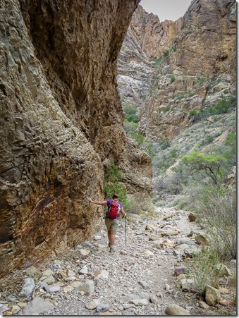
After seeing all the common prickly pear cactus and large blue agave along the first part of the trail, we started approaching the canyon walls and some larger trees.  Things were now starting to look a bit more interesting!  We took each others photos as we walked.

IMG_0895IMG_9288

The bottom of this valley is the lowest point in the whole Chisos Mountain Basin at 4500 feet.  Although rain is still rare here, if it ever does rain, it rolls down the mountains (that completely ring this ancient caldera) and makes its way to the “pour-off” at the end of the trail. 

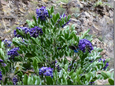
As a result, there is greener plant life here along the canyon floor than many other Chisos trails, including these gorgeous lavender Texas Mountain Laurel trees that were attracting quite a few bees and butterflies!
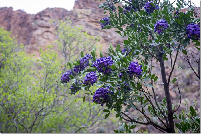
IMG_4358IMG_4360IMG_9295

As we got closer to the end of the trail, some of the trees and shrubs still had their yellow Fall colors, while others were starting to don fresh new Spring green leaves.

IMG_4334-EditIMG_4364-Edit

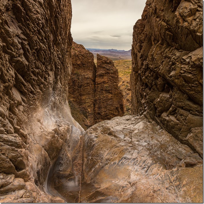
“The Window” pour-off is a v-shaped slot between two large mountain walls that sits many hundred feet above the desert floor that surrounds this Chisos Mountain range.  As we approached the Window, the winds began to increase significantly.  Water pour-offs apparently also make very strong wind tunnels for all the Western desert winds whipping up to meet the Chisos!
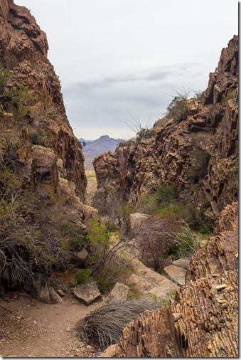
IMG_4353-EditIMG_4347-Edit-Edit

As we reached the very edge of the Window, the rock floor was polished so smooth that it looked as if it was still wet.  Nope, not wet, just slick as hell!   We knew we were on the edge of a cliff, but could not see the bottom directly below us (nor did we wish to slide any closer to that edge to look!).  But this link shows what The Window looks like from the other side…pretty incredible!

I got as close to the edge as I dared for these photos with “the big camera”--

IMG_4340-EditIMG_4341-Edit-Edit

But then it was time to high-tail it away from that ledge!  With the super-strong winds, I was sure glad I brought my wide-brimmed hat with the chin strap for this hike!
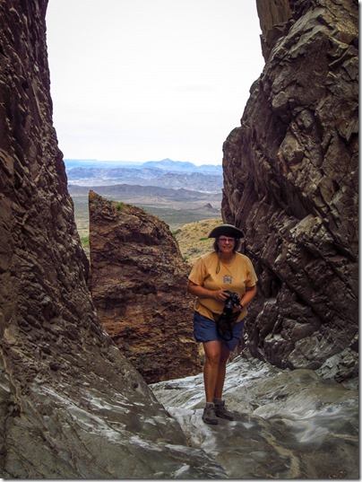
IMG_0932

After literally being “blown away” by The Window, Suzanne and I headed back up the trail to a nice bench to eat our lunches and rest up for the couple hours of uphill climbing ahead.  Surprisingly, the return trip wasn’t all that bad!  I guess a week of all those little pansy hikes had sufficiently limbered up my leg muscles (or maybe my old joints just prefer climbing up rather than down), but I felt like David slaying Goliath and that I could conquer just about anything by the end of this hike!

We returned to the View right on-time to feed Millie her dinner, and tried to determine what next to do with our last evening.  The skies were still cloudy but they were thinning a bit towards the West.  Would this finally be the night we’d see a decent sunset from the Chisos overlook? 

IMG_0865

This was now our third evening at the Basin.  Every night previously, about the only good photos either one of us had gotten was of each other trying to take photos!

Sunset was still a few more hours away, so Suzanne suggested heading over to the Chisos Basin Lodge to take a look around.  The Lodge’s large restaurant smelled pretty appetizing, and after our hike, we were famished!  We were seated with a terrific view of The Window where we’d just hiked from, and our dinners turned out to be quite tasty!

By the time we returned to Millie in the View, the sky was still pretty gray, but there did seem to be a small clearing beneath the cloud layer.  Perhaps the sun would pop out for the last few minutes of the day?  I decided to grab my tripod and head over to the vista.  Suzanne said she’d come join me in awhile if it looked any more interesting.

Within about 5 minutes of my walk, colors began to explode across the sky in all directions!   I had to run the last few yards downhill (with my camera on its tripod) to get to the right vantage point before the light was lost!

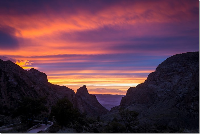
IMG_4381IMG_4386

As I began shooting, I saw Suzanne racing down the trail with her camera!  Glad we could both see these last few thrilling minutes of light to end our terrific week!

IMG_4395

I think I finally now understand why Suzanne (and so many others) become addicted to hiking—the long, slow dance with nature followed by a feeling of complete exhausted elation at the end of a difficult trek.  It’s very, VERY good to be reminded (and reminded often) that your body really can far exceed what your mind ever thinks is physically possible!

Thank you, my friend, for sharing this life-enriching, inspirational secret sauce with me!  I hope we can do even bigger and better hikes together the next time we meet!

IMG_0927


image4

Tuesday, April 8, 2014

G = Great Grapevine Hills Trail & a few updates

G

Thursday morning was “moving day” for Millie and me.  We were moving to our second reserved site for the week at Big Bend National Park’s Rio Grande Village—this one right next to Suzanne’s site.   It was also perfect timing to go refill our fresh water tank at the dump station (since none of the sites here have hookups).

IMG_9253

With that task completed and now all moved in, it was now time to play!  Yesterday’s winds were now gone and we could go do the hike we had planned to the Grapevine Hills Trail.  It was rated as an easy 2 1/4 mile desert hike in the park brochures, so right up my alley (but likely a bit of a bore for Suzanne’s more adventurous hiking legs).

After a 30-mile drive along the park highway, and an additional 6-mile drive down a gravel road, we arrived to the trailhead to pull into the last parking space left in the lot…whew!   Most of the trail was a flat, straight walk along a sandy wash surrounded by mountains of laccolith boulder rocks that reminded me a bit of the giant Jumbo Rocks I’d seen at Joshua Tree National Park a few years ago.

IMG_4288

It was an easy, pleasant walk punctuated with a few photo stops to photograph the blooming yucca.

IMG_9220

Soon, the trail began to steeply climb into the boulder hills providing a magnificent view of the valley below!

IMG_9224

Higher and higher we climbed!

IMG_9226

Now stopping for a few photo ops of each other so we could catch our breath!

IMG_9244IMG_9245

Incredibly, the boulders got larger the higher we climbed!

IMG_4291

After scrambling the summit and carefully making our way around the cliff edge of one final set of big boulders, we saw the trail’s final highlight—Balanced Rock!  Wow, what a thrill!

IMG_4294IMG_4297IMG_4308

Suzanne scrambled down the other side and found a large flat rock where we could sit and admire the view…and what a spectacular view it was!

IMG_4302IMG_4311

We hiked a bit further along the ridgeline to get a few more shots of Balanced Rock (being ever so careful to watch for any snakes sunning themselves on the rocks as the park brochure had warned!)

IMG_4314IMG_4322

This had been my most challenging hike of the week so far, and I (err…Ethel) was feeling absolutely elated and invincible!  Where was all this newfound strength and confidence coming from?

I could just about lift and throw this large boulder with my own two hands!   But alas, I decided to leave it for the next middle-aged woman to claim her victory pose Open-mouthed smile.  I’d be content to just sing the old Helen Reddy song “I am Woman” all the way down the mountain and back to the car!

IMG_9235

==========================================

And now for a few miscellaneous blog updates--

If you read these posts from an RSS reader (like the excellent, free Feedly reader I use!), you might want to click on over to the main WinnieViews blog page to take a look at our new header photo!  As much as I loved the old one, it needed updating to show our newer J-model View, so a quick snap of our new rig at Big Bend did the trick!

While you’re at the blog’s homepage, scroll down and take a look at the “We Recommend” sidebar (as well as my RV Gadget Favs page) for some new items I’ve found and am totally in love with, including these:

BackJoy Relief Seat: Sitting in my straight 90-degree RV dinette bench seat used to be very uncomfortable on my tailbone (especially when starting to stand up again!), but this lightweight, easy-to-store Backjoy seat has now eliminated that pain and, amazingly, makes sitting in the bench seat now a pleasure! 

IMG_9566

Unsure if it was just a fluke, I had Suzanne also try it out on her tailbone, and she’s now a believer too in this space-aged, featherweight little seat!

Travasak Lives Again!: Speaking of RV comforts, I recently discovered that CampingWorld has brought my beloved Travasak bedding system back to life! The original company went bankrupt in 2009, and I was recently lamenting that my old Travasak sheets were starting to look pretty raggedy.  But it now appears CW might be riding to the rescue!  If anyone buys some of the new stuff, let me know what you think!  I’ll probably be in the market real soon to update mine!

IMG_6452

Amazon Link:  Finally, while we’re on the subject of shopping, you may have noticed the Amazon link that’s been appearing at the bottom of my posts lately.  Many bloggers have now become Amazon affiliates.  It lets you help out your favorite blog while doing your regular Amazon shopping.  No additional cost to you, and a few extra pennies to us bloggers trying to keep up with the high cost of cellular bandwidth and diesel fuel to share these posts with our dear readers! Smile 

Well, recently one very thoughtful reader emailed to tell me she’d be making a major $1000+ purchase from Amazon and wanted to be sure I got the affiliate credit for it.  After our email exchange, she clicked my Amazon link to finish up her purchases and buy all the stuff she had been holding in her Amazon Wishlist.  The next day, she excitedly wrote me back “did you get it? did you get it?” (referring to the affiliate credit).

Unfortunately, I did not Sad smile

It turns out that even if you click the link below and see the “winni0b-20” tag at the end of the URL in your web browser’s address bar, Amazon will only credit us for the new items you might add to your shopping cart or wishlist during that session.  Any existing wishlist items that you might be purchasing won’t count (Amazon won’t consider these as being referred by WinnieViews since you had already had them on your Wishlist before using our link). 

So, a slight refinement request for the link text below-- please start your Amazon dreaming and Wishlist-ing from the link!  Amazon will then send a few pennies back to WinnieViews for any of those items you might ultimately purchase from them.  Sincere thanks from Lynne and Millie!


image4

Lynne's Camera Bag

Best RVing Stuff Under $50

Join Us On Facebook